


Sunday, April 4, 2021 - 21:39

There have been a few exciting updates to vessel system over the last couple of weeks, many of them resulting from feedback coming out of the first tactical simulation runs, like the Encounter at P3M-F53T covered in this post
Much of the feedback concerned the lack of an ability to visualise the various aspects of the tactical situation around the vessel. While the 3D TOE grid is useful, it has limitations when it comes to giving a whole picture of what’s going on both in terms of scale and the types of data displayed.
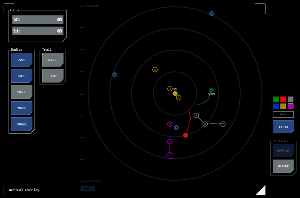 During tactical simulations it quickly became apparent that being able to see where contacts were located relative to the vessel was extremely useful. Commanders in early sims resorted to sketching on tablets to help visualise contact activity and project courses.
A new impulse mapping module was developed to help address this and has been incorporated into tactical and conn consoles. It displays all contacts, the vessel and astronomical objects (AOs) on a 2D map (based on the XY plane). This gives a ‘birds-eye view’ of the tactical situation and makes it easier to keep track of contacts and spot patterns. It’s even possible to draw on the map using a markup tool.
This mapping module has also been incorporated into a brand new panel for the helm. The impulse flight management panel allows a pre-plotted course to be loaded and displays all course points in both a list and in the mapping module. This makes it much easier to keep track of course point details and progress during navigation, something quartermasters previously had to resort to tablets for.
Science
 Prototypes and designs have been released for a number of science systems.
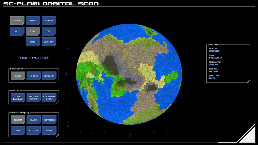
Orbital Scan
A prototype of the first panel for the science console has also been released. It displays orbital scan data for planets after automated analysis of orbital scans. The resulting visualisation provides a high-level overview of a planet so that science officers can identify specific areas for more detailed scanning.
This process provides a high-level understanding of the planet’s geography and climate relatively quickly and means that more time and resource-intensive scans can then be focussed on specific areas of interest.
Active/Direct Scan
 Direct scanning involves bouncing electromagnetic signals off a target and analysing what is returned (similar to the way RADAR works). This makes it possible to visualise what a target object looks like even if not in visual range. When combined with EMDAR it is also possible to get a view of target activity such as engine operation or weapons preparation.
To target an object for direct scanning an active scan is made first. This identifies all objects within range (but also gives away the location of your vessel). One of the detected objects is chosen for scanning.
This system will be used jointly by the science and tactical teams depending on the scenario encountered.
Engineering
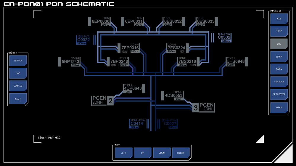 Currently in development are panels for the engineering/operations console which will manage damage control and power distribution functions. Both are closely related as damage to the vessel’s superstructure will often result in disruptions to the vessel’s Power Distribution Network (PDN).
As part of this work, power management functionality will be added to tactical and helm consoles. Currently the training simulator assumes unlimited power but this will soon change to reflect the reality that Endeavour’s reactor will not produce enough power for all systems to be operated at full power simultaneously, especially if damage has been sustained. This will be of particular significance to systems with high power requirements such as the main engines and weapons systems.
Master Systems Monitor
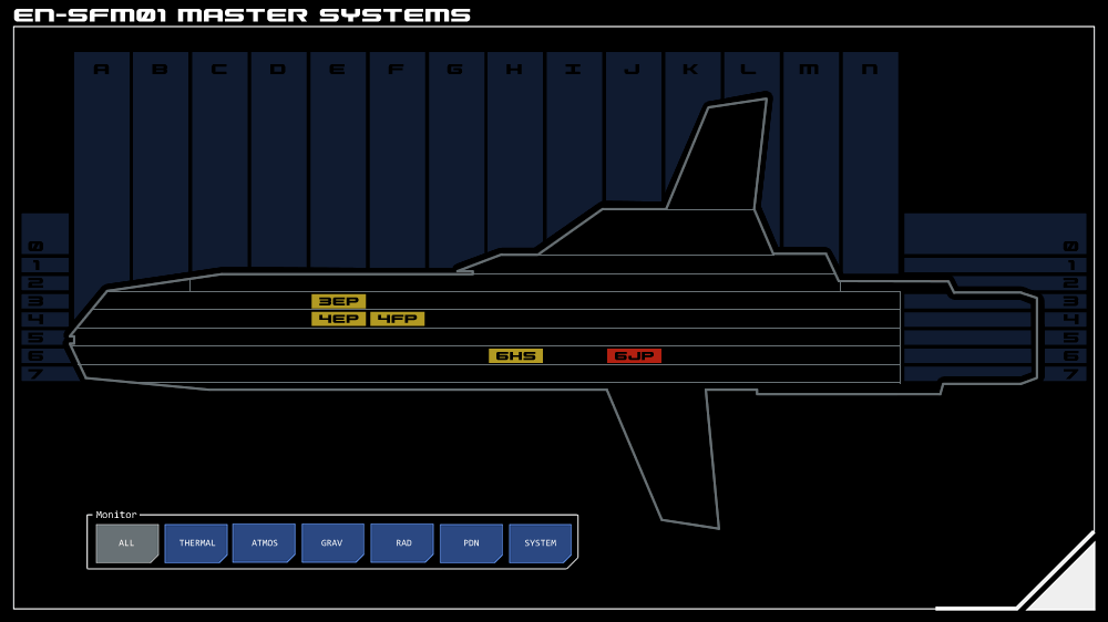 The Master Systems monitor is designed to provide an easily grasped visualisation of alert or alarm conditions across a range of parameters.
The monitor shows a cutaway elevation of the ship divided vertically into decks and horizontally into sections. The position of the alert/alarm indicator provides guidance as to the location of the issue.
A related Deck Systems monitor shows the deck plan for a selected deck with alert/alarm indicators overlaid for more specific location information.
- 2 comments
- Log in or register to post comments
Comments
Course Trails Added
Permalink Submitted by mattm on July 2, 2021 - 11:29
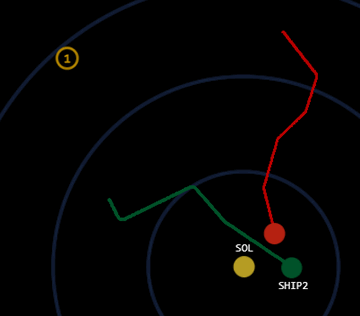 Further update: optional course trails have been added to the impulse mapping module.
When turned on, the vessel's previous course is shown as a 'trail' behind the position indicator for up to five minutes (longer for navigation mode).
In tactical mode, the user can choose to turn on course trails independently the vessel and/or any tracked TSMOs (eample to right shows course trail for both vessel and TSMO).
Updated detail has been added to the impulse mapping module page.
Also, in tactical mode the display of contacts has been updated. Contact indicators are now colour-coded to match their designation with matching colours added to the markup overlay. This reflects the change in approach to contact designation procedure, which someone from tactical will be posting about soon.

Updated Contact Procedure
Permalink Submitted by alexp on July 2, 2021 - 17:49
That would be me... post in the tactical group on the new procedure here.
Concept Site
Immersive sci-fi and how to join the adventure
Crew Site
Information and tools for ISDC crew members


