
Impulse Mapping Module
 The impulse mapping module provides a 2D overview of the position of relevant objects relative to a chosen focal point.
The module has two modes, One is tactical-focussed, the other is navigation-focussed.
Common Features
In either mode, the following functionality is available:
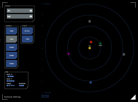
Astronomical Objects (AOs) are also displayed. Stars are represented as yellow dots with the designation displayed below. Planets are shown as blue dots with their system number in the centre.
A point of interest (POI) can be added by tapping the map at the desired location. A purple dot will appear and a dialogue will be displayed at the bottom-left of the module, displaying the grid coordinates of the POI and the range and bearing from the user’s vessel to the POI. Tapping the purple dot clears the POI.
Using the buttons at centre-left, the map's scale can be changed by selecting a new range (which describes the distance from the centre of the overlay along the X and Y axes of the TOE grid). The selected scale is displayed at the top and bottom of the left-hand graticule.
 The focus (or centre) of the map can also be changed to whatever X and Y co-ordinates the user enters using the dialogue at the top-left.
Tapping the currently selected range button will refocus (center) the grid on the vessel's current position.
Overlay Grid Orientation
As with the Impulse Navigation AO Map, the X and Y axes can be flipped to present the overlay in a more intuitive orientation. When active, this “reverse mode” is indicated by a REV symbol in the top-right of the overlay.
Tapping the symbol will toggle between reverse and standard (STD) grid orientations.
Course Trail
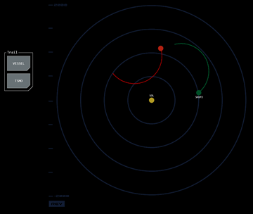
Optionally a course trail showing the vessel's course over the previous 300 maneuvering cycles can be displayed.
Tapping the VESSEL button will toggle the trail for the operator's vessel on or off.
If in tactical mode (see below) tapping the TSMO button will toggle trails for all TSMOs on or off.
The course trail will reset whenever the map is adjusted (eg scale or focus is changed).
Markup
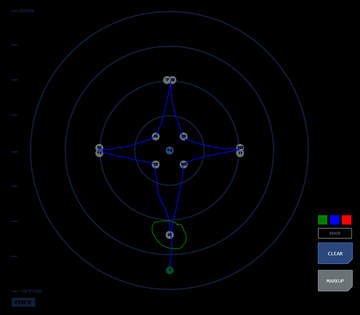
 The module supports markup functionality. If supported by the panel, a markup button (usually but not always below the overlay launch button) will display in ready mode. When the overlay is open, tapping the markup button will display the markup tool dialog. By selecting a colour (default is red), the user can add markup to the overlay using their finger (assuming a touch panel) or mouse, to visualise possible patterns between contacts, project courses, etc.
In tactical mode (see below) six markup colours are offered, corresponding to the colours of the vessel, tracked contacts and each of the four contact designations.
Tapping clear will erase all markup. Alternatively, the overlay can be hidden (but not cleared) by toggling the markup button.
Markup controls may appear in different locations depending on where the mapping module is deployed,
Tactical Mode (Mode 0)
In this mode the module is an extension of the contact board module providing a 2D overview of the Tactical Operating Environment (TOE).
It is presented as a console overlay. The overlay is closed by tapping the bottom-right triangular frame button.
It displays all contacts on the board as a hollow dot with the designation number in the centre. The colour of the dot corresponds to the contact's designation:
- Sierra: SIlver (grey)
- Bravo: Blue
- Victor: Violet (purple)
- Tango: Tan (gold/yellow)
Tracked contacts are displayed as green dots with their database designation displayed below.
The user’s vessel is displayed as a red dot. In this mode the map is centred on the vessel when opened, but remains fixed on this opening position unless adjusted by the user.
Torpedoes fired by the vessel are shown as red hollow dots with the torpedo's ID number in the centre.
Navigation Mode (Mode 1)
In this mode, the module operates in conjunction with a list of co-ordinates (course points) such as a course plotted by a navigator. In this mode the module is integrated into the console.
The focus and range selection panels are displayed to the right of the module.
Course points are displayed on the map as a silver dot with its order number displayed in the middle. One of the course points may be highlighted in green (to show which is currently being navigated, for example).
The modules scale (radius) and focus can be automatically updated with presets when a new co-ordinate list is loaded. The updated focus values will be displayed in the dialog and can be manually overridden by the user.
If the preset scale matches one of the radius button values the appropriate button will be set to active. If the preset scale is a custom value, no radius button will be set to active. In either case, the radius can be manually overridden by the user.


